İTÜ
DERS KATALOG FORMU
(COURSE CATALOGUE FORM)
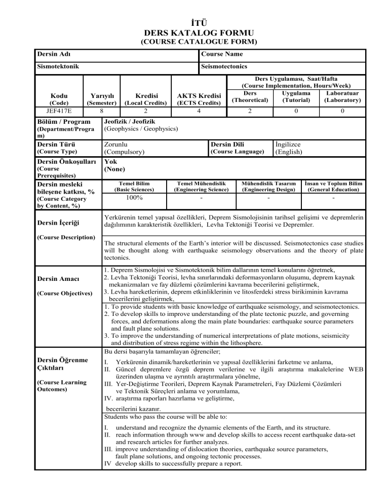
Dersin Adı
Course Name
Sismotektonik
Seismotectonics
Kodu
Yarıyılı
Kredisi
AKTS Kredisi
(Code)
(Semester)
(Local Credits)
(ECTS Credits)
JEF417E
8
2
4
Bölüm / Program
(Department/Progra
m)
Dersin Türü
(Course Type)
Dersin Önkoşulları
(Course
Prerequisites)
Dersin mesleki
bileşene katkısı, %
(Course Category
by Content, %)
Dersin İçeriği
(Course Description)
Dersin Amacı
(Course Objectives)
Dersin Öğrenme
Çıktıları
(Course Learning
Outcomes)
Ders Uygulaması, Saat/Hafta
(Course Implementation, Hours/Week)
Ders
Uygulama
Laboratuar
(Theoretical)
(Tutorial)
(Laboratory)
2
0
0
Jeofizik / Jeofizik
(Geophysics / Geophysics)
Zorunlu
(Compulsory)
Yok
(None)
İngilizce
(English)
Dersin Dili
(Course Language)
Temel Bilim
(Basic Sciences)
Temel Mühendislik
(Engineering Science)
Mühendislik Tasarım
(Engineering Design)
İnsan ve Toplum Bilim
(General Education)
100%
-
-
-
Yerkürenin temel yapısal özellikleri, Deprem Sismolojisinin tarihsel gelişimi ve depremlerin
dağılımının karakteristik özellikleri, Levha Tektoniği Teorisi ve Depremler.
The structural elements of the Earth’s interior will be discussed. Seismotectonics case studies
will be thought along with earthquake seismology observations and the theory of plate
tectonics.
1. Deprem Sismolojisi ve Sismotektonik bilim dallarının temel konularını öğretmek,
2. Levha Tektoniği Teorisi, levha sınırlarındaki deformasyonların oluşumu, deprem kaynak
mekanizmaları ve fay düzlemi çözümlerini kavrama becerilerini geliştirmek,
3. Levha hareketlerinin, deprem etkinliklerinin ve litosferdeki stress birikiminin kavrama
becerilerini geliştirmek,
1. To provide students with basic knowledge of earthquake seismology, and seismotectonics.
2. To develop skills to improve understanding of the plate tectonic puzzle, and governing
forces, and deformations along the main plate boundaries: earthquake source parameters
and fault plane solutions.
3. To improve the understanding of numerical interpretations of plate motions, seismicity
and distribution of stress regime within the lithosphere.
Bu dersi başarıyla tamamlayan öğrenciler;
I. Yerkürenin dinamik/hareketlerinin ve yapısal özelliklerini farketme ve anlama,
II. Güncel depremlere özgü deprem verilerine ve ilgili araştırma makalelerine WEB
üzerinden ulaşma ve ayrıntılı araştırmalara yönelme,
III. Yer-Değiştirme Teorileri, Deprem Kaynak Parametreleri, Fay Düzlemi Çözümleri
ve Tektonik Süreçleri anlama ve yorumlama,
IV. araştırma raporları hazırlama ve geliştirme,
becerilerini kazanır.
Students who pass the course will be able to:
I. understand and recognize the dynamic elements of the Earth, and its structure.
II. reach information through www and develop skills to access recent earthquake data-set
and research articles for further analyzes.
III. improve understanding of dislocation theories, earthquake source parameters,
fault plane solutions, and ongoing tectonic processes.
IV develop skills to successfully prepare a report.
Ders Kitabı
(Textbook)
1.Gubbins, D. (1990).
Seismology and Plate Tectonics, Cambridge University Press, U.K.
2.Fowler, C.M.R. (1990).
The Solid Earth: An Introduction to Global Geophysics, Cambridge University
Press, Cambridge, U.K.
Diğer Kaynaklar
(Other References)
1.Aki, K. and Richards, P.G. (1980).
Quantitative Seismology Theory and Methods Vol. 1 and 2, W.H. Freeman and
Company, San Francisco.
2.Bolt, B.A. (1988).
Earthquakes, W.H. Freeman and Company, New York, USA.
3.Emiliani, C. (1996).
Planet Earth: Cosmology, Geology, and the Evolution of Life and
Environment, Cambridge University Press, Cambridge, U.K.
4.Lay, T. and Wallace, T.C. (1995).
Modern Global Seismology, Academic Press, Inc. San Diego, California, USA.
5.Scholz, C.H. (1990).
The Mechanics of Earthquakes and Faulting, Cambridge University Press, U.K.
Ödevler ve Projeler
Öğrencilere dersi daha iyi anlamaları amacı ile ödev verilecek ve bu ödevler bir
hafta sonra toplanacaktır. Ödev sorularından sınavlarda yararlanılabilir.
All homework problems are to be returned a week after their assignments.
Homework problems may be used as a source for exams.
(Homework & Projects
Laboratuar Uygulamaları
(Laboratory Work)
Bilgisayar Kullanımı
(Computer Use)
Diğer Uygulamalar
(Other Activities)
Başarı Değerlendirme
Sistemi
(Assessment Criteria)
-
Öğrencilere derste tanımlanan problemleri daha iyi kavramaları amacı ile basit
problemlerin çözümünde bilgisayar kullanımına yönlendirilecektir.
Students will be encouraged to improve understanding of basic concepts
investigated by simple conventional computer applications.
Öğrencilere derste verilen ödevlerden veya ilgilendikleri ilginç bir konuyu
seminer şeklinde hazırlayıp sunmaları istenecektir.
Students will be asked to prepare and present an interesting article of their
choices either from homeworks or any other titles in a seminar session.
Faaliyetler
(Activities)
Yıl İçi Sınavları
(Midterm Exams)
Kısa Sınavlar
(Quizzes)
Ödevler
(Homework)
Projeler
(Projects)
Dönem Ödevi/Projesi
(Term Paper/Project)
Laboratuar Uygulaması
(Laboratory Work)
Diğer Uygulamalar
(Other Activities)
Final Sınavı
(Final Exam)
Adedi
(Quantity)
Değerlendirmedeki Katkısı, %
(Effects on Grading, %)
1
30
-
-
4
20
-
-
1
10
-
-
-
-
1
40
DERS PLANI
Hafta
1
2
3
4
5
6
7
8
9
10
11
12
13
14
Konular
Tanışma, Giriş, İçerik, Kaynak Kitaplar ve Not Sistemi
Deprem Sismolojisinin tarihsel gelişimi ve depremlerin dağılımının karakteristik özellikleri.
Levha Tektoniği Teorisi ve Depremler
Litosferin yapısal özellikleri ve kıtasal açılma (rift oluşumu) süreçleri
Açılma merkezlerinin kinematiği ve transform faylar. Levha sınırlarının hareket doğrultuları
(yönleri) ve kayma hızlarının hesaplanmasında/tesbitinde kullanılan sismolojik yöntemler
Yerküredeki levhaların kinematik davranışı ve Euler Kutbu etrafındaki rotasyonlar.
Levhaların üçlü-eklem bölgelerindeki geometrisi ve türlerinin sınıflandırılması
Ödevlerin Değerlendirilmesi ve ARA SINAV-I
Sıkışma tektoniği, dalma-batma zonları. Depremler, Volkanlar ve levha-içi tektonizma
Okyanus Ortası Sırtlar, açılma (yayılma) merkezleri ve depremler
Transform faylar ve dalma-batma zonlarına özgü karakteristik depremler: örnek alıştırmalar
Kıtasal litosfer ve çarpışma zonlarına özgü karaktersitik depremler: örnek alıştırmalar
Kırılma/Yer-Değiştirme Teorileri, Deprem Kaynak Parametreleri, Fay Düzlemi Çözümleri
ve Tektonik Olaylar/Süreçler
Türkiye ve yakın çevresinin sismotektoniği: Doğu Akdeniz Bölgesinden özel problemler
Dönem Ödevi / Projesi: seminer sunumu
Dersin
Çıktıları
-I-II
I-II
II-III
II-III
III
-II-III
III
III
III
III
II-IV
IV
COURSE PLAN
Weeks
1
2
3
4
5
6
7
8
9
10
11
12
13
14
Topics
Introduction, Contents, References and Grading System.
Historical Development of Earthquake Seismology, and the Characteristics of the
Distribution of Earthquakes
The Plate Tectonics Theory and Earthquakes
The Structural Elements of the Lithosphere, and Continental Rifting Processes.
The Kinematics of the Spreading Centers and Transform Faults. Seismological
Methods used in Obtaining Slip Rates and Directions at Plate Boundaries.
The Kinematics of Plates on the Earth’s Surface and Euler Pole of Rotations.
The Geometry of the Triple Junctions and Their Representations.
Evaluation of Homeworks and MID-TERM EXAM – I
Compressional Tectonics and Subduction Zones. Earthquakes, Volcanism, and
Intraplate Tectonics.
Mid-Ocean Ridges, Spreading Centres and Earthquakes.
Characteristic Earthquakes of Transform Faults and Subduction Zones:
the Case Studies.
Characteristic Earthquakes of Continental Lithosphere and Collisional Zones of
Deformation: the Case Studies.
Dislocation Theories, Earthquake Source Parameters, Fault Plane Solutions, and
Tectonic Processes.
Seismotectonics of the Turkey and Surrounding Regions: the Case Studies of Eastern
Mediterranean Region.
Term Paper / Project: seminar presentation
Course
Outcomes
-I-II
I-II
II-III
II-III
III
-II-III
III
III
III
II-IV
IV
Dersin Program Çıktıları ile İlişkisi
Katkı
Seviyesi
1
2
3
Programın mezuna kazandıracağı bilgi ve beceriler (programa ait çıktılar)
Jeofizik mühendisliği kapsamındaki problemlerin çözümü için, temel bilimler, temel mühendislik bilimleri
ve yer bilimlerinin uygulamaları konusunda öğrencilerin bilgi sahibi olması.
Jeofizik verilerinin toplanması için öğrencilerin takım olarak arazi çalışmalarının tasarımını yapma
becerilerinin geliştirilmesi.
Bilişim teknolojilerinin modern alet ve yazılımları ile öğrencilerin toplanan jeofizik verilerini işleme
kapasitelerinin geliştirilmesi.
Öğrencilerin işlenmiş jeofizik verilerini çok disiplinli yaklaşımı kullanarak değerlendirme becerilerinin
geliştirilmesi.
Maden, petrol ve doğal gaz, nadir yer elementleri ve endüstriyel hammaddeleri gibi doğal kaynakların
aranması konusunda öğrencilerin bilgi sahibi olmasının sağlanması.
Toplumun özellikle alt yapı gereksinimleri için doğal afet risk kestirimleri kapsamındaki mühendislik
problemlerindeki tasarım çözümleri konusunda öğrencilerin bilgi sahibi olması.
Yerleşim yeri planlaması çevre ve arkeolojik problemlerin araştırılması konusunda öğrencilerin bilgi sahibi
olması.
Öğrencilerin sözlü ve yazılı olarak araştırmalarının sonuçlarını etkin biçimde sunabilme yeteneğinin
geliştirilmesi, yaşam boyu yeni kavramların öğrenilmesi ve mesleğin uygulamaları konusunda öğrencinin
cesaretlendirilmesi.
Toplum ve insan bilimleri kapsamında toplumun sağlığı ve güvenliği için öğrencilerin mesleki ve etik
sorumluluklarının geliştirilmesi.
1
2
3
4
5
6
7
8
9
X
X
X
X
X
X
X
X
X
1: Az Katkı, 2. Kısmi Katkı, 3. Tam Katkı
Relationship of the Course to the Program Outcomes
Level of
Contribution
Program Outcomes
1
Have the students gain knowledge on the application of basic sciences, basic engineering
sciences and earth sciences for the solution of geophysical engineering problems.
Develop the students’ ability to design field experiments in team works for geophysical data
2
acquisition.
Increase students’ capability to process the collected geophysical data by means of modern
3
hardware and software facilities of information technologies.
Improve the students’ ability to interpret the processed geophysical data by using multi4
disciplinary approach.
Have the students gain knowledge in exploration of natural resources such as mines, oil and
5
natural gas, rare earth materials and industrial raw materials.
Have the students gain knowledge of designing solutions to the engineering problems in terms
6
of natural hazard risk assessments in particular infrastructure needs of the society.
Have the students gain knowledge in site investigation of the environmental and archeological
7
problems as well as settlement planning.
Improve the students’ ability to present the results of investigations by means of oral and
8
written manners effectively and to encourage the life-long learning of the new concepts and
applications of the profession.
Develop the students’ professional and ethical responsibilities for the sake of public health and
9
safety in terms of social sciences and humanities.
1: Little Contribution, 2. Partial Contribution, 3. Full Contribution
2
1
Düzenleyen (Prepared by)
Tarih (Date)
31.05.2013
3
X
X
X
X
X
Onaylayan (Confirming)
X
X
X
X

